 Posted by
Position: 59°40’09.1″N 136°33’26.6″W
Haines Junction in the Yukon Territory is a nexus for visitors to Alaska. Anyone traveling west along the ALCAN (Alaska-Canada highway) passes through Haines Junction. A few hardy souls might leave Whitehorse and head north towards Dawson City, the epicentre of the Klondike Gold Rush. From there you ferry across the Yukon River and endure 150 miles of unpaved road (the Top of the World Highway) before you’re back on solid tarmac near Tok, Alaska. Fearing for Molly’s windshield, we opted instead for the tamer southern route along the ALCAN. On our return leg, we paused in Haines Junction for a night, staying in a slightly dilapidated motel and enjoying a hearty meal at the Mile 1016 Pub.
Kluane NP
 Head south from Haines Junction on Highway 3 and you’ll reach Haines, Alaska, in about three hours. The road skirts the edge of the Kluane National Park and Reserve and quickly became a favourite from the entire trip. As the last vestiges of mankind fell away in the rearview mirror, the park offered us views of not-so-distant snow-covered peaks and promises of wilderness hikes all along the route. The mountains, up to a tide mark, are covered in the low shrubs favoured by the thin soils of tundra. The early autumn reds and golds of the understory were still only being hinted at.
This is not a land of rich arboreal forests. It helped that the day was bright and sunny under almost cloudless skies. In my next life we will bring a canoe and paddle around Kathleen Lake and take an epic backcountry trek. The road climbs steadily to a summit of 3,500’ (1,070m) and then begins a slow descent back into the United States. For the entire trip I think we saw only three other cars. The border crossing was peremptory and professional and took no time at all.
From the border the road runs straight down into Haines. A couple of campgrounds and a viewpoint or two are the only things to distract you. The Chilkat River runs along the righthand side of the road and a long 4,000’ high ridge occupies the lefthand side. Haines straddles a flat-ish piece of land between the Chilkoot and Chilkat Inlets. The original name for the area was Deishú, meaning, ‘the end of the trail’. The indigenous Tlingit used the isthmus as a portage to avoid the long paddle around the Chilkat Peninsula.


Fort Seward
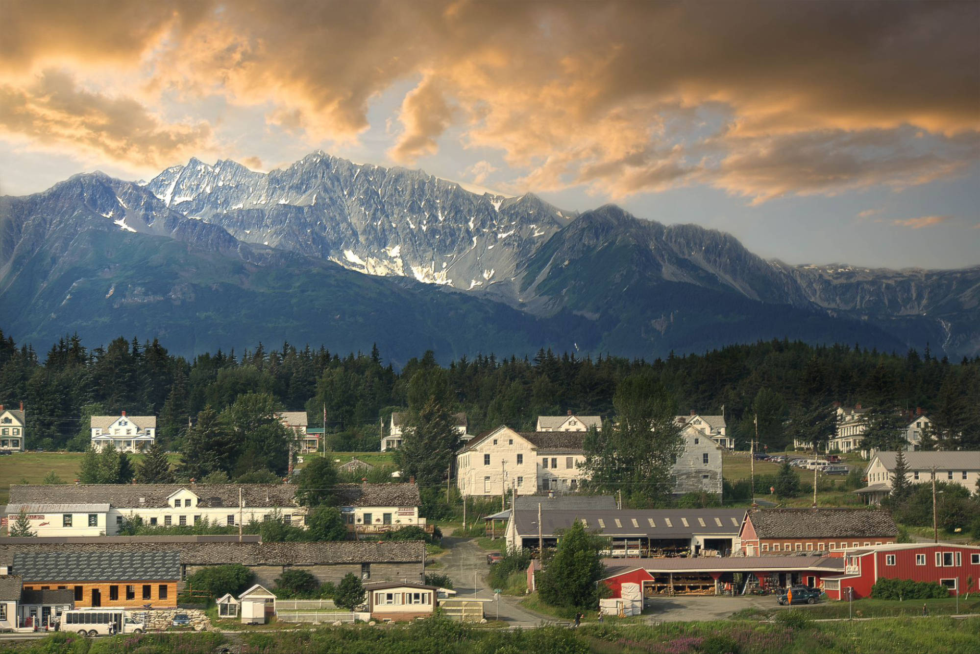
 In the late 1800s when Britain and America were arguing over the border of Alaska and Canada. The original purchase agreement with Russia was a little vague. But when the Klondike Gold Rush took hold, it suddenly made the need for an agreed boundary essential. Fort Seward was authorized by William McKinley in 1898 as part of a regional bulwark against possible British hostilities. Between 1921 and 1925 all the other military installations in Alaska were closed, but Fort Seward maintained a force of 255 soldiers. It remained active until 1945 and today houses an arts colony and a hostel (which we stayed at). We only stayed at the hostel after we learned that the Chilkoot Lake State Recreation Site was closed due to staffing shortages.
Bears
Arriving in town around midday meant we had plenty of time to explore. After a steadying coffee and bun at the Rusty Compass Coffeehouse, our first excursion was up to the campsite to see what we were missing out on. It turns out that we had missed a good deal. The campsite sits at the bottom of the very picturesque Chilkoot Lake. Tall, snow laden mountains tumble down to the lake’s calm waters giving it a distinctly Alpine vibe. When we arrived, we wandered out on the floating dock for a clearer view of the surroundings. As sailors we are naturally drawn to docks as flies are to manure. Long lines of kayaks were moored up, seemingly ready to paddle out onto the lake. Then we took a walk through the campground, just to check things out.
By the time we returned to the car a group of people had formed with all eyes and cameras focussed on the dock. Looking in that direction, we spotted a mama bear and four cubs clowning around on the dock where we’d just stood. Alaska State Parks describe Chilkoot Lake, with its annual salmon run, as a ‘bear highway’. Bears and fisherfolk line the river when the salmon are running, which they were. I was very happy our bear bells had jingled all the way through our walk around the campground.


e-Biking
 Our first night in Haines we stayed at an AirBnB just south of town and dined on indifferent Thai food. The following morning, Carol had determined we should rent e-bikes and explore the area while pretending we were getting exercise. Our first stop was Chilkat State Park on the southern end of the Haines fjord. The 9,837-acre park offers 35 campsites at the end of a gravel road and 14% downhill grade. The terrain is hilly and tree covered. The spine of the isthmus reaches up nearly 1,500’. The end of the trail gave us a view southward towards Sullivan Island and, if we squinted hard enough, Juneau.
On the east side the inlet is favoured by cruise ships heading up to Skagway. Haines has a cruise ship dock suitable for smaller vessels only. That means the crowds of 15,000 people that swarm Skagway when five cruise liners arrive simultaneously don’t occur in Haines. That keeps the place folksy and calm. So much so that local grizzlies can be found all over town during the season. Certainly, we saw no end of bear scat during our bike ride.
Chilkat River
From the park we burned through many electrons riding back up the steep hill back towards town and then onto the other state park, Chilkoot, that we had driven to the previous day. By lunchtime we’d covered about 45 miles and were getting low on energy. At the bike rental shop, the owner asked if we wanted fresh batteries. ‘Sure!’ we said and he duly swapped in a fresh charge. With that we pointed our bikes northwards back towards the Canadian border to better take in the views along the Chilkat River.
Like most of Alaska’s rivers, this one appears untouched by the US Army Corps of Engineers and retains is broad plain of twisting rivulets and its stony grey riverbed for most of its length from the border. I doubt even a kayak could get through without scraping along the bottom for miles. From the road we had an expansive view of the mountains to the west. Many of the snow-covered peaks reach 5,000’ and more. At our backs, the 7-mile Saddle Trail ran east across Mount Rapinsky, itself reaching up 3,000’ and more.


Locks
E-bikes are tediously heavy – Carol’s weighed 85lbs. and mine a feathery 65. Compared with my old 17lb. road bike they’re a bit Sisyphean. Riding one is a lot like pushing a rock uphill all day. At least motorcyles have the honestly to not trick you into believing you can ride one without the engine running. In any case, by mid-afternoon, 65 miles in, we were done and returned the bikes to the rental shop.
The owner was busy painting a house and texted us to just leave the bikes outside the office. Don’t worry, no one will steal them, he said. No one locks anything in Haines. We took him at his word and made our with Molly to the Haines Hostel. Which is less of a hostel and more of a hotel with a shared kitchen. As we put our bags away, Dylan, the owner, asked if we’d seen the bear walking across the paddock in front of the hotel. Sadly, we’d missed her, but it spoke to the fluid relationship Haines has with its bears.
Haines Hostel
 Dylan is built like a bear and walks, lumbers really, shoulders forward like one. Perhaps a lifetime of wilderness guiding in Alaska assimilates you. After living in Skagway for 20 years, he pitched it all on and bought the hostel. It opened in mid-June. For years the building had been a bed & breakfast, until Covid shut it down. Then, for five years, it was a rooming house. Now it’s a hostel. The view from our window looked out over Fort Seward and down the hill to the modest cruise ship dock, with big glacier-laden mountains in the background. The weather was warm enough for us to open our windows and invite a cross-breeze in. Dylan can’t be fagged to make breakfast for his guests. Good for him. Being chipper and engaging first thing in the morning, every morning, must be exhausting. Besides, people can be very picky about their eggs.
To round off our day, we popped into the Port Chilkoot Distillery for a taste of their wares a half hour before they closed for the day. When Carol found a pair of locally made earrings we got only slightly more than we’d bargained for.
Mount Riley
For our second full day in Haines, we hiked up Mount Riley. A shorter, shallower hike than the one up Mount Ripinsky, it still took about three hours to summit the 1,758’ (536m) hill. Our reward was a spectacular 360-degree view of the peninsula, the river and fjord. Steep and treacherous hiking through long switchbacks latticed by overgrown roots required steady, not speedy, progress.
That evening, we learned from one of the other guests that a landslide had blocked the road north out of Skagway to the Yukon. We cared because Skagway and the Yukon were the next stops on our itinerary. Skagway’s draw as a cruise ship terminal meant lucrative excursions into the north country were put on hold due to the slide. Crews from both sides of the border were busy trying to clear the mess and keep the short summer economy running. Dylan said the road closes fairly frequently, but that these days most commodities are brought in by sea on Mondays and Tuesdays. Like islanders in the Bahamas, locals crowd the shops early on delivery days.


511
I reasoned that if we spent a couple of nights in Skagway that might be enough time to clear the road, and we shouldn’t change our Marine Highway booking for the following morning. Indeed, by the time we woke up, 511 Yukon already indicated that traffic was making its way around the obstruction. With that incentive, we bundled everything into Molly and headed for the ferry terminal. Anyway, both of us were itching to get back on the water.


I remain charmed by your adventures, escapades, noticings and recountings.
Thanks Brad! I appreciate your continued engagement!
Amazing photos, Mike. Looks spectacular. (Hope you had a long lens for the bear shots.)
Thanks Steve! Sadly I only had a short lens. Next time I’ll do better! Every time I pass a photogenic neon sign I think of you and try to get a decent shot.